In much of the northern hemisphere, but especially in Europe, this summer has been much warmer and drier than average. More than 2/3 of the continent has received much less rainfall than the long-term average over the past three months, and extreme heat waves have also hit the continent.
The causes must be examined at global, regional and local levels.
For the second year in a row, the Eastern Pacific Ocean is experiencing a so-called La Niña phenomenon, which this time is only slowly losing its strength this time. La Niña is a major cooling of ocean temperatures in the central and eastern equatorial Pacific, coupled with changes in the tropical atmospheric circulation, namely wind, pressure and precipitation anomalies. It generally has the opposite effect on weather and climate as El Niño, which is the warm phase of the so-called Southern Oscillation (ENSO).
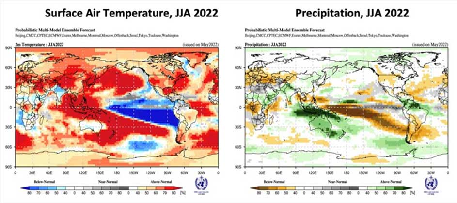
Figure 1 Distribution of temperature and precipitation on Earth according to WMO. The figure on the left shows the extensive La Niña in the Pacific (blue) and warmer than average near-surface temperatures (red). The figure on the right shows that Europe and North America receive much less rainfall than average. Source: WMO
La Niña leads to cooler-than-average ocean water temperatures, so less moisture and saturated water vapor is released into the atmosphere, without which there is no precipitation.
The latent heat of water vapor evaporating into the atmosphere in tropical areas, when entering to the temperate zone, transfers significant heat energy to the temperate cyclones by condensation, but now the lack of moisture is weakening them.
Overall, the temperate zone tends to have a deficit water balance, i.e., more precipitation falls than evaporates from the surface into the atmosphere. Cyclones need moisture, so the system makes up the shortfall from the tropics via so-called conveyor belts. The conveyor belts can be thought of as a system of pipes that connects the supplier to the consumer.
Our continent is particularly vulnerable to these moisture imports. If sufficient moisture reaches the temperate zone, cyclone activity is more intense, and more precipitation falls. And as cyclones move further south, more moisture can enter the zone, making Europe's weather wetter. However, if little moisture arrives from the tropics, as it did this year and last year, the cyclones that provide the precipitation will shift northwards to lower latitudes (one reason being that water can condense at lower temperatures) and be replaced by dry, hot anticyclones with strong cloud-dispersing power. Anticyclones are very massive, difficult to move and can only be “broken” by strong cyclones, the kind that are now “missing”.
Another reason for the persistent dry weather is the lack of rainfall since the second half of 2020 and the drying out of the top 0-200 cm of soil. Plants are also unable to evaporate, and not enough moisture is released into the atmosphere, so the local effects of summer, which cause so-called thunderstorms, are not occurring. As the atmosphere gets warmer, it needs more saturated water particles to form precipitation. (Atmospheric water, or water vapor, plays a very complex role in shaping the weather. The warmer the air, the more water vapor it can absorb without becoming saturated. The higher the temperature, the more moisture it needs for condensation.) Unfortunately, unsaturated water vapor is also a potent greenhouse gas, which further induces the temperature rise observed in the intensity of heat waves. The combination of lack of precipitation and dry, warm air leads to intense, extreme drought.
Extreme rainfall shortages are causing problems across Europe. Nearly 45% of the European Union is at risk of severe rainfall shortages, so the drought that has been affecting many European regions since the beginning of the year could spread and become more severe.
Rainfall shortages affect energy and food production
The lack of rainfall affects river flows and reduces the amount of water stored, which has a negative impact on the energy sector and the capacity of hydropower plants. In Spain, the volume of water in reservoirs is currently almost 40 percent below the ten-year average, while in Portugal the amount of water used for hydropower generation is half the average of the previous seven years. Until the beginning of July, river power generation was lower than the 2015-2021 average in several European countries, in particular in Italy (-5039 GWh compared to the average), France (-3930 GWh) and Portugal (-2244 GWh). The same decrease is also true for the level of hydropower reservoirs, affecting Norway, Spain, Romania, Montenegro and Bulgaria, among others. This water shortage is reducing or suspending hydro and thermoelectric power generation operations in some countries.
France is experiencing a yield loss of 80% in maize, wheat and other cereal crops. The situation is equally critical in Hungary, where the weather has already caused HUF 650-700 billion in damage to agriculture. Water shortages and high temperatures will reduce crop yields in almost all countries, with preliminary estimates directly damaging the economy by EUR 50-150 billion.
Dozens of rivers and hundreds of streams have dried up in central Europe. Italy's longest watercourse, the Po, has dried up, but the Ebro in the Iberian Peninsula has also reached critical levels. 4/5 of European rivers are below average flow and more than 350 lakes have dried up on the continent.
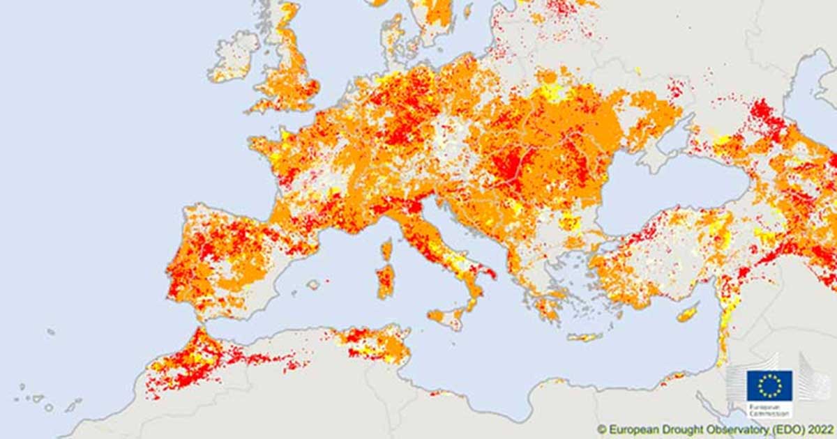
Figure 2 Areas affected by rainfall deficits in Europe, first half of July 2022. Source: EDO
How long will it last?
Although La Niña is weakening, it is forecast to continue throughout the year with a 20-50% probability in the Pacific, and temperatures in the central and subtropical Atlantic have started to rise.
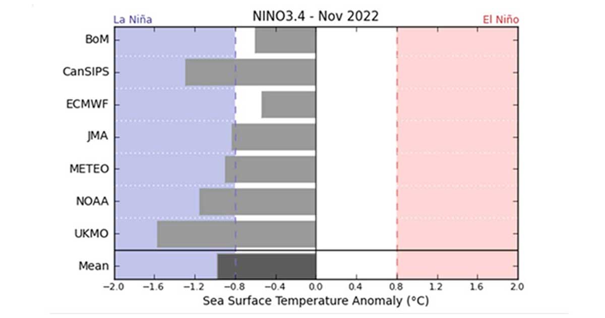
Figure 3 The expected strength of La Niña and the anomaly in Pacific Ocean sea surface temperatures estimated by various meteorological models in autumn 2022. Source: Australian Bureau of Meteorology/WMO
At the end of the summer half-year, condensation is more likely to start in the cooling air, and as the accumulated moisture causes it to occur at higher temperatures, more active cyclonic activity with more intense precipitation is expected in the northern hemisphere. This will be coupled with the fact that subtropical cyclones and hurricanes will bring more moisture to the westerly winds region.
Hopefully this dry spell will end in the autumn or winter and will not become permanent.
What about us?
In Hungary, the Great Plain is the most exposed to drought, and is also at the highest risk of persistent and severe drought. Unfortunately, the current weather situation exemplifies this well. In the 20th century, periods of drought were frequent, even lasting for years, and they will become much more regular in the future, especially in summer. The occasional lack of precipitation and drought in our country is part of Hungary's climate, but the intense warming of recent decades has made summers significantly hotter, and more and more intense heat waves are intensifying and exacerbating the drought.
Extreme weather risks, including heat waves, floods and severe, extreme droughts, are becoming more frequent and severe in the Carpathian Basin.
What can we do for the future of Hungarian agriculture?
Decision-makers and stakeholders in vulnerable and sensitive sectors must prepare now for the extremes of the future. The Orbán government has reacted quickly to the current situation and farmers are receiving substantial help to mitigate the damage. The Cabinet and the Ministry of Agriculture are doing all they can to support farmers in this exceptional situation. A five-point action plan has been proposed by the recently established Drought Steering Committee. It proposes opening a HUF 3 billion fodder transport aid facility for farmers in difficulty, and the government will impose a repayment moratorium from September 2022 until the end of 2023 on investment and working capital loans for agricultural businesses. In addition, farmers will be able to resubmit their applications for exceptional water use and the procedure for insurance companies to assess drought damage and pay out drought damage compensation will be speeded up.
As Prime Minister Viktor Orbán said in Tusványos, we need to exploit two very important assets. One is that Hungary has a unique plant gene bank, a unique gene bank system, and we can continuously breed and develop seeds that are adapted to the changing climate and weather. The other is that Hungary needs to capture the rainfall, because in wet periods a lot of rainfall flows through the country. This backlog of 30-40 years needs to be solved as soon as possible in the near future.
Source:
https://met.hu/ismeret-tar/erdekessegek_tanulmanyok/index.php?id=3200
https://met.hu/ismeret-tar/erdekessegek_tanulmanyok/index.php?id=3198
Water Information: Bureau of Meteorology (bom.gov.au)
https://klimapolitikaiintezet.hu/elemzes/ev-legforrobb-napjai-klimavaltozas
https://klimapolitikaiintezet.hu/cikk/a-szaharaban-hoeses-kanadaban-hoseg
Cover photo: István Nagy's facebook